During an eruption, if the wind is from the east at 10,000 feet (outflow), the tephra will fall on Vancouver, Canada in about an hour. This Page Hyperlinked [click on] Mount Baker Stratovolcano (background)© ™ ®/ Kulshan Stratovolcano© ™ ®, Simon Fraser University (foreground)© ™ ® ~ Image by Stan G. Webb - In Retirement© ™ ®, An Intelligent Grandfather's Guides© ™ ® next, The Man From Minto© ™ ® - A Prospector Who Knows His Rocks And Stuff© ™ ®
Learn more about the Cascadia Volcanic Arc© ™ ® (Part of Pacific Ring of Fire) Cascadia Volcanoes© ™ ® and the currently active Mount Meager Massif© ™ ®, part of the Cascadia Volcanic Arc© ™ ® [ash flow, debris flows, fumaroles and hot springs], just northwest of Pemberton and Whistler, Canada ~ My personal interest in the Mount Meager Massif© is that the last volcanic vent blew north, into the Bridge River Valley [The Bridge River Valley Community Association (BRVCA), [formerly Bridge River Valley Economic Development Society], near my hometown. I am the Man From Minto© ™ ® - A Prospector Who Knows His Rocks And Stuff© ™ ® The 2010 Mount Meager landslide was a large catastrophic debris avalanche that flowed to the south, into the Lillooet Valley British Columbia, Canada, on August 6 at 3:27 a.m. PDT (UTC-7). More than 45,000,000 m3 (1.6×10⁹ cu ft) of debris slid down Mount Meager, temporarily blocking Meager Creek and destroying local bridges, roads and equipment. It was one of the largest landslides in Canadian history and one of over 20 landslides to have occurred from the Mount Meager massif in the last 10,000 years. Although voluminous, there were no fatalities caused by the event due in part to its remote and uninhabited location. The landslide was large enough to send seismic waves more than 2,000 km (1,200 mi) away into the neighboring U.S. states of Alaska and Washington and beyond. Multiple factors led to the slide: Mount Meager's weak slopes have left it in a constant state of instability. The massif has been a source of large volcanic debris flows for the last 8,000 years, many of which have reached several tens of kilometres downstream in the Lillooet River valley., to the south. It is arguably the most unstable mountain massif in Canada and may also be its most active landslide area. And on the north side lies Downton Lake Hydro Reservoir, impounded by the La Joi Dam, the uppermost of the Bridge River Project dams. The earliest identified Holocene landslide was in 7900 BP (before the present, or read it as the number of years ago). Further landslides occurred in 6250 BP, 5250 BP, 4400 BP, 2600 BP, 2400 BP, 2240. BP BP, 2170 BP, 1920 BP, 1860 BP, 870 BP, 800 BP, 630 BP, 370 BP, 210 BP, 150 BP and in 1931, 1947, 1972, 1975, 1984, 1986 and 1998. These events were attributed to structurally weak volcanic rocks, glacial unloading, recent explosive volcanism and glacial activity. Those who dance with earthquakes and volcanoes are considered mad by those who cannot smell the sulfur. We begin to deal with BIG (MEGA) EARTHQUAKES at Simon Fraser University (foreground) Kulshan Stratovolcano© / Mount Baker Stratovolcano (background)©New Cascadia Dawn© - Cascadia Rising - M9 to M10+, An Intelligent Grandfather's Guide© next, ~ Images by Stan G. Webb - In Retirement©, An Intelligent Grandfather's Guides©Countdown to Earthquake Drill - International Great ShakeOut Day is on Thursday, October 20, 2022 at 10:20AM, and annually on the 3rd Thursday in October thereafter - - I grew up in small towns and in the North where the rule is share and share alike. So, I'm a Creative Commons type of guy. Copy and paste ANY OF MY MATERIAL anywhere you want. Hyperlinks to your own Social Media are at the bottom of each post. Creative Commons License
This work is licensed under my Creative Commons Attribution 4.0 International License.

Friday, August 28, 2015

ShakeAlert: Earthquake Early Warning Simulation of M8.0 Cascadia Offshore Earthquake

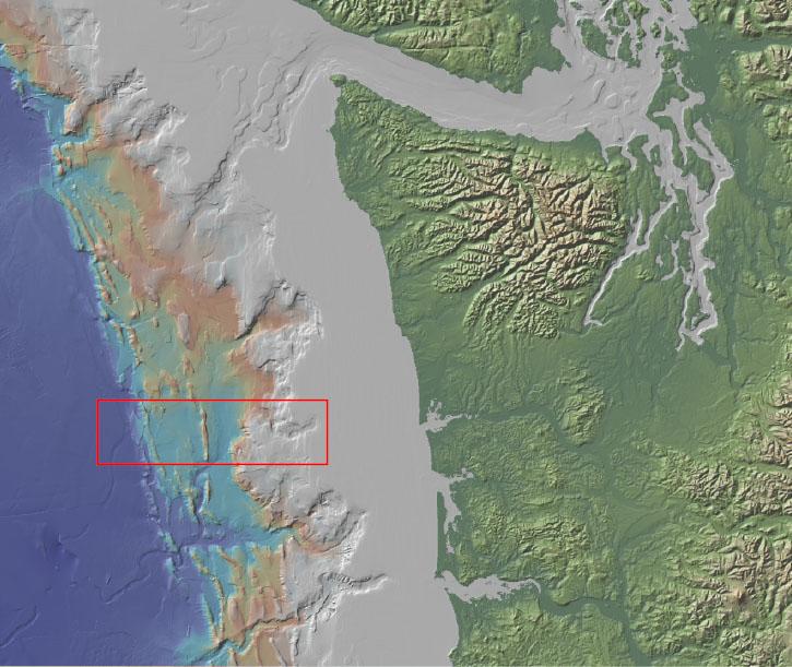
Cascadia Fault off Northwest Coast of North America


>> Sound On >> Best viewed Full Screen >> Darkened Room (1:01 minutes)


To monitor earthquake and volcanic activity across the Pacific Northwest, herein meaning the states of Washington and Oregon. The University of Washington and the University of Oregon cooperatively operate the Pacific Northwest Seismic Network (PNSN). The PNSN is sponsored by the U.S. Geological Survey (USGS), the U.S. Department of Energy, the State of Washington, and the State of Oregon. Beginning in 1969 with five seismometers, the PNSN has grown to more than 300 seismograph stations distributed across the region and become the second largest seismic network in the United States. The PNSN is an organization dedicated to reducing impacts of earthquakes and volcanic eruptions in the states of Washington and Oregon by providing accurate and fast information about earthquakes and ground motions to scientists, engineers, planners, and the public.
Our headquarters is at the Department of Earth and Space Sciences at the University of Washington. However, we have offices and personnel in several locations in the region, seismic stations spread far and wide over the two states, and deep collaborations with other institutions inside and outside of Cascadia that make it a bit of a challenge to define sharply our organizational boundaries.
PNSN operates a number of stations collaboratively with other agencies. These stations might well be considered part of the PNSN network.

PNSN also incorporates in our analyses seismic data provied by other agencies and seismic networks. These contributed data are graciously shared by our partners:

No comments:

Post a Comment